Geomorphic versus Climatic Drivers of Changing Coastal Flood Risk
|
Thomas Wahl (Co-PI), University of Central Florida
Project Period: June 2019 to May 2022
Total Funding Amount: $1,200,000 |
Collaborators: Philip Orton (PI), Stevens Institute of Technology
James Booth (Co-PI), City University of New York Stefan Talke (Co-PI), Portland State University / California Polytechnic State University |
Project Description.
Coastal flooding is one of the most dangerous and damaging natural hazards that societies face, and coastal development and climate change are causing a dramatic rise in vulnerability. Since the 19th century, estuary channels have typically been deepened and widened by a factor of two or three, harbor entrances have been deepened and streamlined, and a large proportion of wetlands have been filled over and replaced with neighborhoods. Such geomorphic changes increase flood risk by reducing natural resistance to storm surge and tides. Similarly, sea level rise and climate-modulated variations in storm characteristics such as intensity, size and track path also alter flood risk. The overarching goal of the proposed research project is to reveal and contrast the mechanisms by which these geomorphic and climatic changes alter flood risk. This goal will be met using a combination of computational modeling, historical climate and storm surge data analysis, and theory-based synthesis. It will improve the well-being of communities within urbanized harbors and estuaries by highlighting coastal development practices that can worsen coastal flooding. The project plan increases scientific literacy and engagement, and connects the research to applications through interactions with local stakeholders and governments, as well as the US Geological Survey and the US Army Corps of Engineers.
Coastal flooding is one of the most dangerous and damaging natural hazards that societies face, and coastal development and climate change are causing a dramatic rise in vulnerability. Since the 19th century, estuary channels have typically been deepened and widened by a factor of two or three, harbor entrances have been deepened and streamlined, and a large proportion of wetlands have been filled over and replaced with neighborhoods. Such geomorphic changes increase flood risk by reducing natural resistance to storm surge and tides. Similarly, sea level rise and climate-modulated variations in storm characteristics such as intensity, size and track path also alter flood risk. The overarching goal of the proposed research project is to reveal and contrast the mechanisms by which these geomorphic and climatic changes alter flood risk. This goal will be met using a combination of computational modeling, historical climate and storm surge data analysis, and theory-based synthesis. It will improve the well-being of communities within urbanized harbors and estuaries by highlighting coastal development practices that can worsen coastal flooding. The project plan increases scientific literacy and engagement, and connects the research to applications through interactions with local stakeholders and governments, as well as the US Geological Survey and the US Army Corps of Engineers.
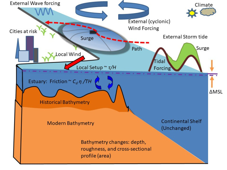
Processes affecting coastal flooding in modern versus historical estuaries. Storm surge is formed mainly by wind over water, and acts together with tidal forcing to produce a storm tide. This external wave is modified by local bathymetry and wind: Converging width (as shown) amplifies heights, frictional effects damp (reduce) the wave, and tide/surge waves interact nonlinearly. Historical estuary bathymetry was shallower, more rough, and included more wetlands and intertidal areas. Geomorphic change affects local wind setup (by changing estuary surface area and the ratio of surface stress τ to depth H). Moreover, estuarine alterations also reduced frictional effects on wave amplitude η, both thru decreased drag coefficient Cd and increased depth H. Change in timescale T –set by the speed, size, and path of a cyclone, for a surge—also impact magnitudes.
The project will improve the understanding and separation of climatic and geomorphic factors in coastal flooding through several elements of novel research and technical innovation. The investigators will use a unique tide-gauge data set that extends back to the 19th century together with contemporary, retrospective, and idealized hydrodynamic models to elucidate system sensitivities. Well-known, simplified insights into tidal dynamics will be tested for storm surge, then used to help interpret how altered local topography, bathymetry and wetland area have changed frictional damping and long-wave mechanics. A combined analysis of climate, storm characteristics, and morphologic change will identify the modes and pathways through which climate variability and bathymetric change modulate storms surges. Advanced non-stationary univariate and multivariate statistical models will be developed and employed to incorporate these changes and assess how statistical properties relevant for coastal design and risk assessments respond. A flood model inter-comparison workshop will help quantify relevant modeling sensitivities, which will help to improve estuary and floodplain predictions for the academic and operational forecasting community.
|
Funding agency/program: National Science Foundation, Prediction of and Resilience to Extreme Events (PREEVENTS)
|
|
|
|
|

|
|
Copyright © Coastal Risks & Engineering Lab, University of Central Florida, Orlando, Florida.
All Rights Reserved.
Website developed and maintained by Javed Ali.
All Rights Reserved.
Website developed and maintained by Javed Ali.
