Changes in seasonal sea level. The seasonal cycle is a very important and energetic sea level component. It is comprised of annual and semi-annual cycles whose amplitudes and phase shifts were long thought to be relatively constant. We investigated the temporal variations of the seasonal harmonics throughout the 20th and early 21st century along the U.S. Gulf coast and found a significant amplification of the annual sea level cycle from the 1990s onwards in the eastern part of the Gulf. This leads to lower winter and higher summer sea levels, which in turn has the potential to increase the impacts of hurricane storm surges because they meet higher base water levels. Our results suggest that changes in the air surface temperature towards warmer summers and colder winters and changes in mean sea level pressure explain most of the amplitude increase. The results were published in Geophysical Research Letters.
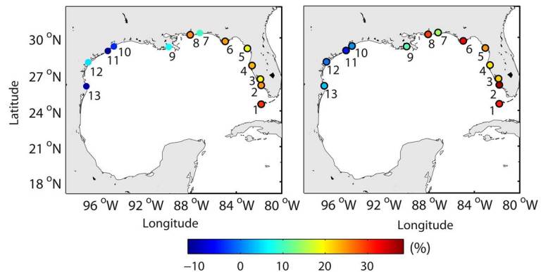
The left side of the figure shows the observed changes (expressed in percent) in the amplitude of the annual sea level cycle in the Gulf of Mexico. The right side shows our reconstruction with the statistical models we developed.
Erosion risk. In order to better understand the implications of the seasonal sea level changes we extended the analysis to important wave parameters. We then explored how the combined changes in sea level and the wave climate at multi-decadal and seasonal time scales have altered the erosion risk in the northern Gulf over the last three decades and how it may change in the future. We found that long-term trends in the relevant variables have caused an increase of ~30% in the erosion/flooding risk since the 1980s. In the next decades, sea level rise will likely become the dominating driver and may in combination with ongoing changes in the wave climate escalate the erosion/flooding risk by up to 300% over the next 30 years. Changes in the seasonal cycles of sea level and significant wave height have also caused a considerable increase of the erosion/flooding risk in summer and decrease in winter (superimposed onto the long-term trends). The results were published in Geophysical Research Letters.
At shorter time scales sea storm events of stochastic nature are responsible for beach erosion and flooding. It is the combination of different variables such as high waves and high water levels that determine how large the impacts of extreme events are. The limited amount of observational data we have available only provides a snapshot of the variability inherent to these drivers of coastal erosion and flooding. We developed a multivariate statistical model that is capable of simulating millions of artificial sea storm events preserving important joint correlations between different variables. With this this model we found, for example, that design-relevant total water levels (resulting from the combination of tides, storm surges and wave action) could be significantly larger than currently thought. This has immediate implications for coastal risk assessments and managers and planners. The results were published in the Journal of Geophysical Research.
Compound flooding. In a study published in the journal Nature Climate Change, we assembled long historical records of rainfall, tide gauge readings and hurricane tracks to assess the simultaneous occurrence of heavy precipitation on land and storm surges. The combination of these two – heavy rain and storm surges driven mainly by the wind from storms – can result in “compound” floods. We found that along large coastline stretches around the U.S., a systematic linkage exists between the two important drivers for coastal flooding, making it more likely that the two occur in tandem. Our analysis showed that over the past century, the number of compound flood events for many US coastal cities has increased.
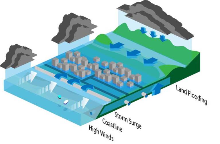
Compound flooding explained: the coincident occurrence of precipitation and storm surge (large enough to cause flooding or slow down or fully block freshwater drainage) and lead to compound flooding in coastal regions.
Storm surge decadal variability. Global mean sea level rise is a major concern because storm surges resulting from extra-tropical or tropical storms meet higher base water levels. Any additional changes in the storm surge climate itself could further increase or decrease the negative impacts. Several studies have suggested that at long (centennial) time scales there was no evidence in the past for significant changes in storm surge water levels and future projections for the end of this century are very uncertain. Hence, in our analysis we focused more on coastal management time scales and explored multi-decadal variations in the storm surge climate. We found that such fluctuations exist and are significant along most coastline stretches along the U.S. It means that over longer time scales of a few decades it is much more likely in certain areas that damaging storm surges occur compared to other time periods. These findings were published in the Journal of Geophysical Research.
In order to better understand the drivers of these multi-decadal changes we also studied the links to large scale climate and found that much of the variability can be explained with changes in sea surface temperature and sea level pressure over the Atlantic, Pacific, and the U.S. mainland. The results that were published in a second paper were the first step on our way to be able to predict how the storm surge climate may look like in the coming decade(s); such information would be crucial for coastal communities to mitigate the associated risks.
In order to better understand the drivers of these multi-decadal changes we also studied the links to large scale climate and found that much of the variability can be explained with changes in sea surface temperature and sea level pressure over the Atlantic, Pacific, and the U.S. mainland. The results that were published in a second paper were the first step on our way to be able to predict how the storm surge climate may look like in the coming decade(s); such information would be crucial for coastal communities to mitigate the associated risks.
Project period: 2013 to 2016. Funded by: German Academic Exchange Service (DAAD), U.S. Geological Survey (USGS) and NASA
|
|

|
|
|
|
|

|

|
Copyright © Coastal Risks & Engineering Lab, University of Central Florida, Orlando, Florida.
All Rights Reserved.
Website developed and maintained by Javed Ali.
All Rights Reserved.
Website developed and maintained by Javed Ali.
