Compounding effects of Storm Surge, Sea Level Rise, extreme Rainfall and Water Table on Urban Flooding in Southeast Coast of Florida
|
Phase I
Funded Period: Jan. 2019 - Sept. 2019 Total Funding Amount: $50,000 |
Phase II
Funded Period: June 2020 - Nov. 2021 Total Funding Amount: $75,000 |
Project Description.
Modeling associated with Flood Protection Level of Service (FPLOS) requires consideration of astronomical tides and storm surge, extreme rainfall associated with various return periods, and initial water table all of which have a significant influence on the depth and duration of flooding in coastal basins. Typically, the modeling strategy includes modeling of extreme rainfall magnitudes of various frequencies in the range of 5-100 years. The hydrologic/hydraulic modeling system used for coastal basins also requires downstream boundary conditions at the water control structures which discharge flood waters to the ocean. During extreme storm events water level downstream of the District structures (known as “tailwater”) will be elevated due to astronomical tides and storm surge and waves. In south Florida, the astronomical tides have a seasonal variation with higher water levels during the months of September to November which may be exacerbated by perigean spring tides. To date, FPLOS projects have used extreme water levels at the ocean boundary of the model using a statistical approach for determining design conditions for various frequencies as in the case of rainfall. Assuming coincident frequencies for rainfall and ocean-side water level, as currently assumed in the FPLOS studies, is too conservative and the FPLOS program envisions an approach where joint-probability of occurrence of these two or more random variables in future planning studies to determine the current level of service and develop adaptation strategies. Projected sea level rise is also considered in the development of such strategies. To complicate matters further, modeling specially in urban areas also needs to consider position of the water table at the beginning of the simulation period as it may have a profound effect on the extent of flooding. Water table elevations are expected to increase under future sea level rise scenarios and they must be incorporated in simulations for future conditions.
Up to middle of 2019 there were no established practices for obtaining joint probabilities of storm surge and extreme rainfall although many papers on the subject can be found in the literature. Basically, there are two or more random variables (e.g. extreme rainfall, extreme water level at the structure outlets) each of which has a marginal probability distribution and some cross-correlation. A third random variable relevant to this study is the position of the initial water table prior to the extreme storm event. A reasonable assumption is that the compounding of rainfall, storm surge and groundwater level events, which do not fall necessarily in the highly extreme range, may produce a combined event with high extreme conditions (high risk) at the coastal site.
During 2019, the South Florida Water Management District (SFWMD) sponsored a pilot study with the National Center for Integrated Coastal Research at the University of Central Florida (UCFCoastal) aimed at deriving methodologies to obtain the joint probability distribution of the random variables capable of generating extreme conditions at coastal sites. Methodologies based on the use of copulas and multivariate non-linear regression models were derived (Jane et. al, 2020) and applied to coastal sites located in Biscayne Bay. Tailwater stages for these locations are measured on the sea-side of water control structures operated by the SFWMD. The analyzed sites were S-20, S-22 and S-28.
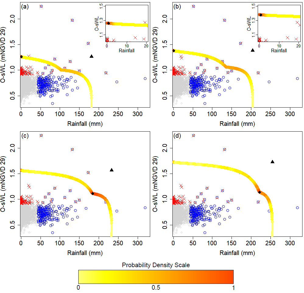
Comparison of the design events obtained by accounting for the dependence between rainfall and Ocean-side Water Level (O-sWL) (diamonds) and under the assumption of full dependence between the two drivers (triangles) for return periods of (a) 10-years, (b) 20-years, (c) 50-years and (d) 100-years.
Borrowing from the results in the initial study, the SFWMD is interested in continuing with a second phase, which will include the following specific tasks:
- Provide additional training and guidance to SFWMD staff in understanding the technical aspects of the methodology and the developed computer code derived during the first phase of the study.
- Provide support in making the code more user friendly and more suited to FPLOS SFWMD applications. For instance, generation of combinations of events all for a given risk, presented to the user in tabular and graphical format.
- Provide support to District staff in the application of the methodology to additional coastal sites located in the East Coast of Florida, in Broward and Palm Beach counties. Also, investigate the application of the methodology to locations other than at the East Coast of Florida. One site on the west coast of the SFWMD facing the Gulf of Mexico (to be selected later on), a second site would be structure S-79 on the Caloosahatchee River, and a third site would be structure S-65E, connecting the Kissimmee River to Lake Okeechobee.
- Explore the determination of annual probabilities of failure curves for coastal structures operated by the SFWMD. This will require the determination of fragility curves and its integration over a wide range of hydrologic/hydraulic loadings.
|
Funding Agency: South Florida Water Management District
|
|
Relevant Publication
Jane, R., Cadavid, L., Obeysekera, J., and Wahl, T., Multivariate statistical modelling of the drivers of compound flood events in South Florida, Natural Hazards and Earth Systems Science (Discussion), https://doi.org/10.5194/nhess-2020-82, in review, 2020.
Jane, R., Cadavid, L., Obeysekera, J., and Wahl, T., Multivariate statistical modelling of the drivers of compound flood events in South Florida, Natural Hazards and Earth Systems Science (Discussion), https://doi.org/10.5194/nhess-2020-82, in review, 2020.
|
|
|

|

|
Copyright © Coastal Risks & Engineering Lab, University of Central Florida, Orlando, Florida.
All Rights Reserved.
Website developed and maintained by Javed Ali.
All Rights Reserved.
Website developed and maintained by Javed Ali.
